Log in
All resources
Create a design
1,674 Free Images of Military Maps
the comprehensive history of england (1876)
english-language maps showing history
1870s maps showing history
bibliothèque nationale de france
maps in the library of congress
engraving
grabados
fondo antiguo
libros del siglo xviii
18th century books
the comprehensive history of england (1876)
english-language maps showing history
the comprehensive history of england (1876)
english-language maps showing history
the comprehensive history of england (1876)
english-language maps showing history
the comprehensive history of england (1876)
english-language maps showing history
the comprehensive history of england (1876)
english-language maps showing history
the comprehensive history of england (1876)
english-language maps showing history
the comprehensive history of england (1876)
english-language maps showing history
the comprehensive history of england (1876)
english-language maps showing history
the comprehensive history of england (1876)
english-language maps showing history
the comprehensive history of england (1876)
english-language maps showing history
the comprehensive history of england (1876)
english-language maps showing history
the comprehensive history of england (1876)
english-language maps showing history
the comprehensive history of england (1876)
english-language maps showing history
the comprehensive history of england (1876)
english-language maps showing history
the comprehensive history of england (1876)
english-language maps showing history
maps by nicolas sanson
1730s maps of france
army of the grand duchy of lithuania
maps of hrodna by braun & hogenberg
maps of hrodna by braun & hogenberg
historical images of hrodna
maps of the duchy of mantua
guillaume sanson
french-language maps
ambroise tardieu
maps in the library of congress
1863 maps
landais & oberthur
maps from gallica
maps of hrodna by braun & hogenberg
historical images of hrodna
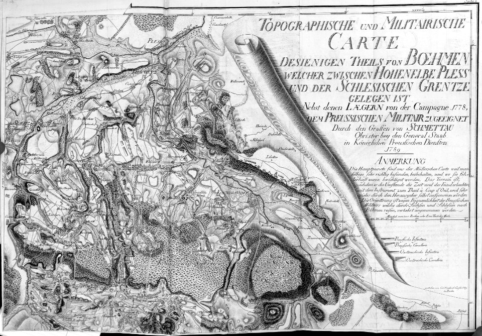
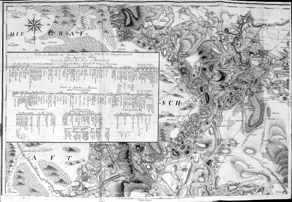
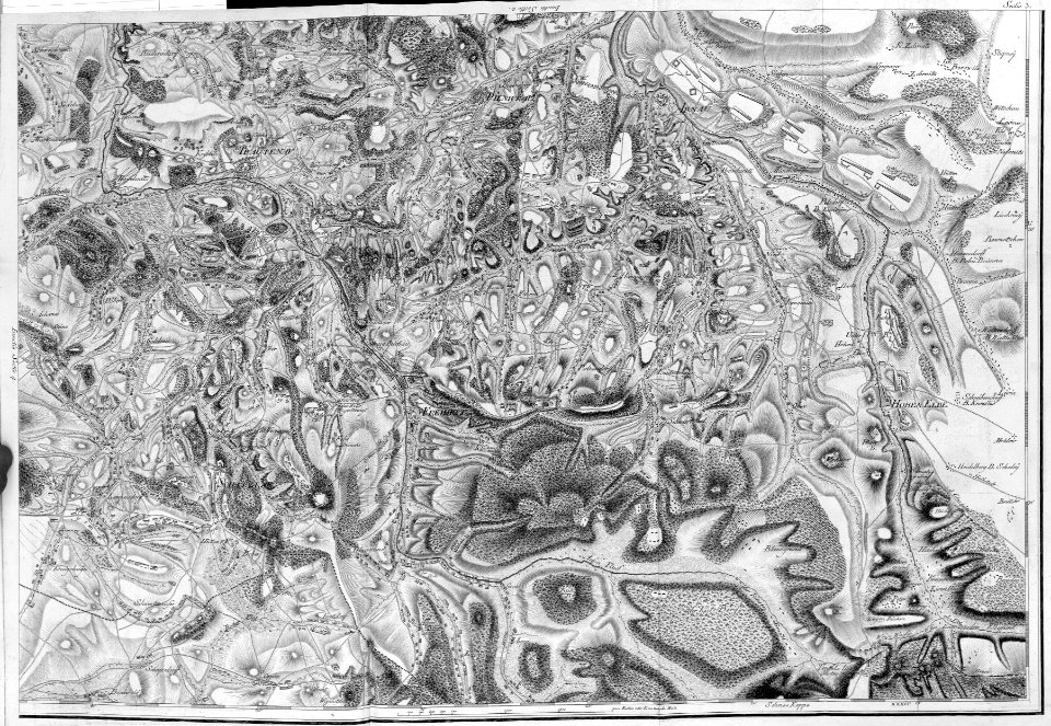
zehn karten und ansichten den schlachtfelden des amerikanischen unabhängigkeitskreiges in den staaten pennsylvanien und new york
maps in the library of congress
zehn karten und ansichten den schlachtfelden des amerikanischen unabhängigkeitskreiges in den staaten pennsylvanien und new york
maps in the library of congress
maps from the earth and its inhabitants, vol. vi
maps of the history of russia
architecture
exterior
paintings in the musée de la marine de toulon
émile vernet-lecomte
history icons
maps on icons
cornelis huyberts
guillaume sanson
the comprehensive history of england (1876)
english-language maps showing history
the comprehensive history of england (1876)
english-language maps showing history
the comprehensive history of england (1876)
english-language maps showing history
the comprehensive history of england (1876)
english-language maps showing history
the comprehensive history of england (1876)
english-language maps showing history
the comprehensive history of england (1876)
english-language maps showing history
the comprehensive history of england (1876)
english-language maps showing history
the comprehensive history of england (1876)
english-language maps showing history
the comprehensive history of england (1876)
english-language maps showing history
military
maps
china, the scenery, architecture, and social habits of that ancient empire
paintings of the qing dynasty
old maps of portobelo
maps by emanuel bowen
cartography
maps
battle of hampton roads
maps of virginia
old maps of the polish-lithuanian commonwealth
1790s maps of poland
maps of the new york and new jersey campaign
maps showing 1776
maps in the library of congress
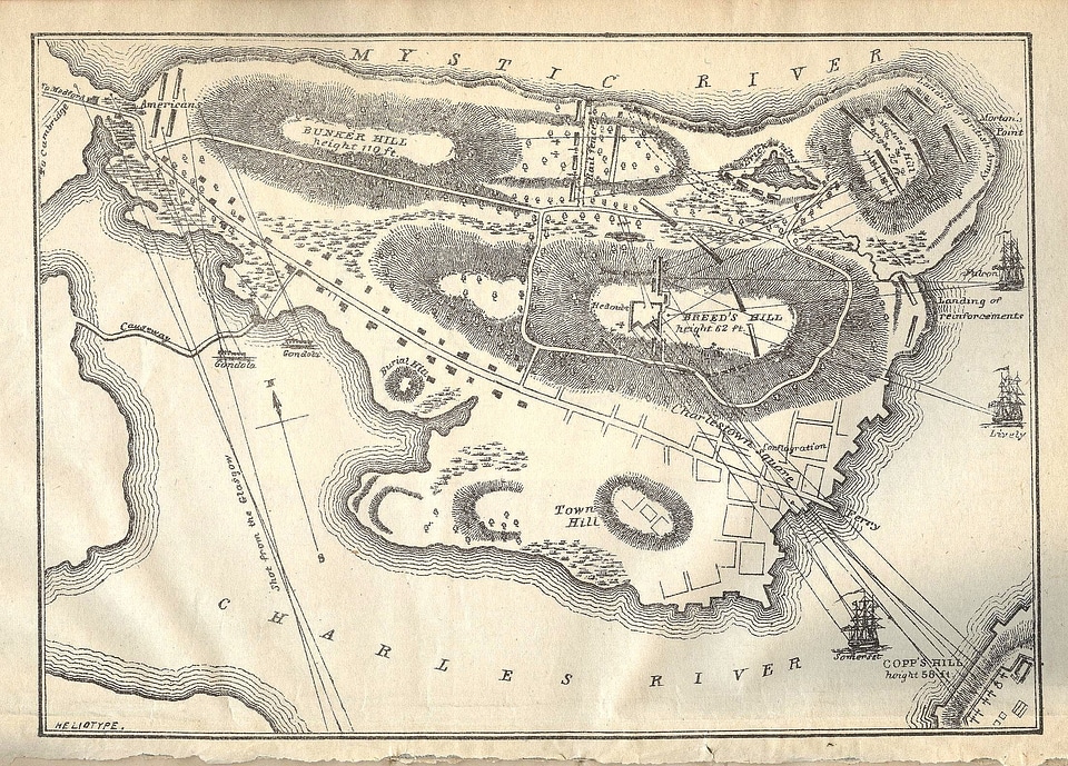
1777 maps of boston
robert loyd-lindsay, 1st baron wantage
walter william ouless
portraits by charles-philippe larivière
neoclassicism
cartography
maps
cartography
maps
with the armies of the balkans and at gallipoli (1880)
maps of the military history of bulgaria
map of the upper rhenian circle by sanson
1690s maps of hesse
école du service de santé militaire (lyon)
postcards of lyon
cartography
maps
zehn karten und ansichten den schlachtfelden des amerikanischen unabhängigkeitskreiges in den staaten pennsylvanien und new york
maps in the library of congress
zehn karten und ansichten den schlachtfelden des amerikanischen unabhängigkeitskreiges in den staaten pennsylvanien und new york
maps in the library of congress
zehn karten und ansichten den schlachtfelden des amerikanischen unabhängigkeitskreiges in den staaten pennsylvanien und new york
maps in the library of congress
anti-catholicism in art
budenovkas in art
cartography
maps
zehn karten und ansichten den schlachtfelden des amerikanischen unabhängigkeitskreiges in den staaten pennsylvanien und new york
maps in the library of congress
zehn karten und ansichten den schlachtfelden des amerikanischen unabhängigkeitskreiges in den staaten pennsylvanien und new york
maps in the library of congress
cartography
maps
cartography
maps
maps from gallica
baroque
the comprehensive history of england (1876)
english-language maps showing history
the comprehensive history of england (1876)
historical images of st. james's palace
1810s maps of the iberian peninsula
1813 maps of spain
daniel de la feuille
1708 maps
correspondence of the national park service
north carolina monument, gettysburg
bodleian library, notitia dignitatum 1436
anti-catholicism in art
budenovkas in art
a plan of the operations of the king's army under the command of general sr. william howe, k.b. in new york and east new jersey, against the american forces commanded by general washington, from the 12th. of october, to the 28th. of november 1776
battle of white plains
the comprehensive history of england (1876)
english-language maps showing history
1794 maps of the holy roman empire
english-language maps of europe
old maps of lima
joseph mulder
military
maps
imperial war museum first world war artwork
émile eugène belin
maps in the library of congress
1779 maps of new york (state)
carte de la moldavie pour servir à l'histoire militaire de la guerre entre les russes et les turcs - levés par l'etat-major sous la direction de f.g. de bawz... echelle de 10 heures de moldavie, 50... - btv1b53100577d
leonard schenk jansz.
carte de la moldavie pour servir à l'histoire militaire de la guerre entre les russes et les turcs - levés par l'etat-major sous la direction de f.g. de bawz... echelle de 10 heures de moldavie, 50... - btv1b53100577d
leonard schenk jansz.
carte de la moldavie pour servir à l'histoire militaire de la guerre entre les russes et les turcs - levés par l'etat-major sous la direction de f.g. de bawz... echelle de 10 heures de moldavie, 50... - btv1b53100577d
leonard schenk jansz.
carte de la moldavie pour servir à l'histoire militaire de la guerre entre les russes et les turcs - levés par l'etat-major sous la direction de f.g. de bawz... echelle de 10 heures de moldavie, 50... - btv1b53100577d
leonard schenk jansz.
pierre antoine tardieu
françois houiste
military
people
military cartographic institute (prague)
jiří čermák
carte de la moldavie pour servir à l'histoire militaire de la guerre entre les russes et les turcs - levés par l'etat-major sous la direction de f.g. de bawz... echelle de 10 heures de moldavie, 50... - btv1b53100577d
leonard schenk jansz.
carte de la moldavie pour servir à l'histoire militaire de la guerre entre les russes et les turcs - levés par l'etat-major sous la direction de f.g. de bawz... echelle de 10 heures de moldavie, 50... - btv1b53100577d
leonard schenk jansz.
a plan of the operations of the king's army under the command of general sr. william howe, k.b. in new york and east new jersey, against the american forces commanded by general washington, from the 12th. of october, to the 28th. of november 1776
iona island (new york)
everett d. graff collection of western americana
maps by g. w. & c. b. colton & co.
dillingen an der donau
baroque
harpers ferry, west virginia
john e. weyss
maps of petropavlovsk-kamchatsky
peredvizhniki
17th-century paintings in unidentified private collections
baroque
franz müller
carl schütz
prints by abraham allard in the rijksmuseum amsterdam
maps in the rijksmuseum amsterdam
carl gustaf emil mannerheim in unidentified year
romanticism,symbolism,romantic nationalism
17th-century maps of vienna
bartholomeo camuccio
17th-century maps of vienna
bartholomeo camuccio
the comprehensive history of england (1876)
buildings in england
1301 - 1400 of 1,674
Next page
/ 17


![[Ten maps and views of the battlefields of the American Revolutionary War in the states of Pennsylvania and New York], 1777](https://cdn.creazilla.com/illustrations/10001455242/ten-maps-and-views-of-the-battlefields-of-the-american-revolutionary-war-in-the-states-of-pennsylvania-and-new-york-1777-md.jpg)
![[Ten maps and views of the battlefields of the American Revolutionary War in the states of Pennsylvania and New York], 1777](https://cdn.creazilla.com/illustrations/10000484458/ten-maps-and-views-of-the-battlefields-of-the-american-revolutionary-war-in-the-states-of-pennsylvania-and-new-york-1777-md.jpg)


![[Ten maps and views of the battlefields of the American Revolutionary War in the states of Pennsylvania and New York], 1777](https://cdn.creazilla.com/illustrations/10000597684/ten-maps-and-views-of-the-battlefields-of-the-american-revolutionary-war-in-the-states-of-pennsylvania-and-new-york-1777-md.jpg)
![[Ten maps and views of the battlefields of the American Revolutionary War in the states of Pennsylvania and New York], 1777](https://cdn.creazilla.com/illustrations/10001450663/ten-maps-and-views-of-the-battlefields-of-the-american-revolutionary-war-in-the-states-of-pennsylvania-and-new-york-1777-md.jpg)
![[Ten maps and views of the battlefields of the American Revolutionary War in the states of Pennsylvania and New York], 1777](https://cdn.creazilla.com/illustrations/10000887733/ten-maps-and-views-of-the-battlefields-of-the-american-revolutionary-war-in-the-states-of-pennsylvania-and-new-york-1777-sm.jpg)


![[Ten maps and views of the battlefields of the American Revolutionary War in the states of Pennsylvania and New York], 1777](https://cdn.creazilla.com/illustrations/10000506393/ten-maps-and-views-of-the-battlefields-of-the-american-revolutionary-war-in-the-states-of-pennsylvania-and-new-york-1777-md.jpg)
![[Ten maps and views of the battlefields of the American Revolutionary War in the states of Pennsylvania and New York], 1777](https://cdn.creazilla.com/illustrations/10001122410/ten-maps-and-views-of-the-battlefields-of-the-american-revolutionary-war-in-the-states-of-pennsylvania-and-new-york-1777-md.jpg)


![Vienna à Turcis obsessa & Deo Dante A Christianis eliberata. Scala Perticarum Rynlandicarum 100 [=Om. 064; 1: 25 000 environ]. Cum Privilegio Coesareo Sumptibus Authoris Dommeco. Rosetti scul, Domenico Rossetti, 1683](https://cdn.creazilla.com/illustrations/10001270042/vienna-turcis-obsessa-deo-dante-a-christianis-eliberata-scala-perticarum-rynlandicarum-100-om-064-1-25-000-environ-cum-privilegio-coesareo-sumptibus-authoris-dommeco-rosetti-scul-domenico-rossetti-1683-sm.webp)
![Vienna a Turcis obsessa, & Des dante a Christianis diberata. Scala Perticarum Rynlandicarum 100 [=Om; 062; 1: 6 000 environ]. Cum Privilegio Caesarea Sumptibus Authoris, Dome[ni]co Rossetti scul, Domenico Rossetti, 1692](https://cdn.creazilla.com/illustrations/10000857324/vienna-a-turcis-obsessa-des-dante-a-christianis-diberata-scala-perticarum-rynlandicarum-100-om-062-1-6-000-environ-cum-privilegio-caesarea-sumptibus-authoris-domenico-rossetti-scul-domenico-rossetti-1692-sm.webp)
